Check Out Our Holiday Auction!

Forecast for the Moab Area Mountains

Dave Garcia
Issued by Dave Garcia on
Thursday morning, December 4, 2025
The avalanche danger is MODERATE on steep slopes near and above treeline that face NW-N-NE-E. Human-triggered soft slab avalanches failing on a buried persistent weak layer are possible on these slopes. The danger is most prominent on any slope where the overlying soft slab has gained some cohesion. Alpine terrain that has had any amount of previous wind loading is most concerning. Even though today's avalanches are likely to be shallow and confined to small pockets, they could still have serious consequences due to our thin early-season snowpack.
Conditions remain very thin, and rocks, stumps, and logs lurk below the surface everywhere. There still isn't quite enough snow for real turning and riding. Exercise extreme caution getting around.
Low
Moderate
Considerable
High
Extreme
Learn how to read the forecast here
Special Announcements

Geyser Pass Road Conditions: The road will be closed this morning for plowing. Plow crews will have the gate closed until sometime this afternoon.

It's Avalanche Awareness Week!

Saturday, December 6 - 18th Annual Utah Snow and Avalanche Workshop (USAW). This session will be available to live stream or attend in person at the Wasatch Jr High School Auditorium. 3750 S 3100 E, Salt Lake City, UT 84109. Information and tickets are available here.

Saturday, December 13 - Moab Winter Kick Off Party at the MARC Bring your skis or board to wax, listen to live music, and bring in another winter season with our local community. Tickets available online now!

Friday, January 30 - Saturday, January 31 - Moab Backcountry 101 Class - Our annual local backcountry avalanche class. Click here for information and registration. Moab and Monticello locals can use the discount code MOAB-LOCAL for a 10% discount.

Weather and Snow

24 Hour Snow: 0" 72 Hour Snow: 0" Season Total Snow: 21" Depth at Gold Basin: 17"

Winds on Pre-Laurel Peak: 15 NNW Temp: 7° F

Weather

Under clear skies, it is a chilly 7°F this morning in Gold Basin. High temperatures will reach 20°F with sunny skies and very light winds out of the northwest. A prolonged series of moisture will bring accumulating snow to the mountains of northern Utah and Colorado through Sunday. Unfortunately, it looks like southeast Utah will be left out of the action this time. I don't see anything particularly promising in our near future. However, northwest flow with plenty of available moisture will continue into next week. Confidence is low, but it is possible some of these shortwaves could drop further south into our zone. Stay tuned.

General Conditions

Travel was somewhat difficult while cruising around the Laurel Highway and Gold Basin on Tuesday. I found deep trail breaking off the beaten path that made for slow going. The average height of snow above 10,000' is 18-24". The snowpack is weak and faceted, allowing skis to punch deep when skiing downhill and attempting to make turns. Rocks and logs are a real hazard right now, and the punchy snow doesn't help. The good news is that soft powder exists on all aspects, so if you can find a grassy slope, you might be able to make some turns.

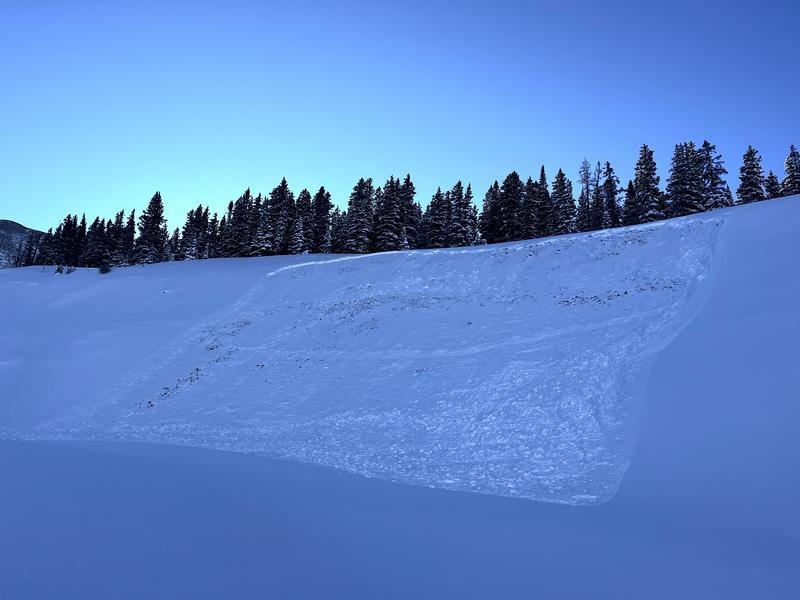
Old, pre-existing faceted snow was buried by 9 inches of storm snow on Sunday, laying an evenly distributed soft slab on top of a persistent weak layer. We observed numerous small avalanches on Monday, and test results continued to be sensitive on Tuesday. Avalanche danger is most prevalent on northerly aspects where the snowpack is deeper and more well-connected. The weak layer is sensitive, and above treeline slopes that have seen just a touch of wind-drifted snow are especially suspect.

Poor snowpack structure also exists on slopes that face west and southwest. Many slopes near or above treeline with a west or southwest aspect were subject to strong sun and/or strong winds and do not have much of a snowpack at all. The PWL problem does not exist on these slopes. However, if you find yourself on southwest or west-facing slopes, and the snowpack is deep, dig down and look for the weak layer; it is easy to find.

Click here to check out all recent obs, including my fieldwork from Tuesday.

Check out the video below from our fieldwork on Monday

Snowpack and Weather Data

NEW! Gold Basin webcam storm stake

Gold Basin Storm Stake (10,000')

Recent Avalanches
In our travels on Monday, we came across this R2 D2 natural avalanche in Colorado Bowl. Definitely large enough to bury a person.
Avalanche Problem #1
Persistent Weak Layer
Type
Location
Likelihood
Size
Description

Sunday's storm deposited a very soft slab that now sits on top of weak faceted layers of older snow. In many areas, this slab is still too soft to produce an avalanche, but where it has gained cohesion—especially in wind-loaded terrain—avalanches large enough to bury a person are possible. Slopes with a northerly or easterly component to their aspect are the most suspect. Backcountry observers continue to report shallow slabs breaking on facets at the old snow surface in stability tests.

The photo below, from my fieldwork on Tuesday, illustrates the results of an extended column test (ECTP 9) with a soft slab failure on facets at the old snow surface.

Additional Information

Thanks to everyone who attended our Know Before You Go session on Wednesday night!

It's never too early to start thinking about avalanches. Here are a few things to consider doing:

  • Learn online. We have over 5 hours of free online learning at the Know Before You Go website
  • Check out the upcoming in-person Know Before You Go events HERE
  • Sign up for an on-snow class
  • Check out the UAC's education progression HERE
  • Get your avalanche rescue gear ready for winter. Put fresh batteries in your transceiver and update the firmware. Inspect your shovel and probe. Get your airbag backpack ready by possibly doing a test deployment and updating the firmware if it is an electric version or getting your canister refilled if it's not electronic.
General Announcements
This forecast is from the U.S.D.A. Forest Service, which is solely responsible for its content. This forecast describes general avalanche conditions and local variations always occur.